Thursday, November 4, 2010

When Transit Oriented Development Disappoints

Rail~Volution 2010 was great. I'm very thankful to have been able to go to Portland this year. We expect great transit in large cities like Boston (which hosted Rail~Volution last year), but it's more refreshing to see a mid-size metro area that has invested in transit for that last 25 years.

There are so many great lessons to be learned when a thousand transit-oriented development folks gather in one place. What I'd like to focus on is when TOD doesn't work, or when it looks different from what we might expect or prefer.

The highlights of the week for me were the two field trips to TOD sites. The first was east to Gresham, the second west to Beaverton and Hillsboro.

East Side

In 1986, Gresham was a working-class town that became the eastern terminus of Portland's first light rail service, the Blue Line. It's still a working-class town with very little "gentrification" evident. Transit-oriented development appears confined to a few new buildings near stations, and a shopping center.

The TOD does follow the new urbanist principles of mixed use, residential over commercial. In the shopping center, the parking will eventually be located underground or beneath commercial-residential buildings. Otherwise, there's little to distinguish it from other recent developments. Well, perhaps the fact that it's recent development is a distinguishing feature in itself, since very little development has taken place recently.

Most of the eastern Blue Line runs in the middle of a wide boulevard. It wasn't a boulevard until the light rail was built, though - and lots of engineering work had to be done to mitigate the widening and leveling of the original two-lane roadway. The cost of building the line included re-doing hundreds of driveways, lawns, fences, and retaining walls. And though the neighborhoods don't look well-to-do, they certainly don't look run-down or impoverished except in one or two old warehouse districts where the loft/office refurbishing trend hasn't quite taken off.

A couple of things were disappointing. One was the new county office building whose front is turned away from the Gresham Central Transit Center, as if to ignore its presence. Another is the new station at Civic Drive being built within 30 yards of a new mixed-use development, with no architectural connection to it. In many parts of the world, developers and mall owners are eager to attach their space as closely as possible to rail stations. In most Japanese cities and towns, the railway station is the central shopping center, crowded not only with travelers and commuters, but with shoppers. There seems no physical reason why electric rail vehicles can't run through the middle of a shopping center here in the US, too. Federal transit legislation for years has encouraged public-private partnership in the construction of transit stations. So why aren't we doing it? In this case, the answer was, "Hmmm, well, we had this Federal grant to built the station, so we just did it." It has a (very nice) outdoor platform covered with a (very nice) glass roof, but is basically an outdoor space. What a shame the concept of integrating transportation and shopping just isn't part of most planners' thinking here in the US.

So on Portland's east side, light rail appears to provide a foundation to keep property values steady without overly inflating them. TOD has been modestly successful, and there is likely to be more as the economy recovers.

West Side

Beaverton and Hillsboro are in the opposite direction from Gresham on the Blue Line, both geographically and socially. Where Gresham is mainly working class, the west side is predominantly middle class and high-tech. In fact, Beaverton and Hillsboro were small towns up through the 1960s. Change came in the late 1960s when the Sunset Highway became a freeway, built to speed access to downtown Portland across the Tualatin Mountains from the west. Light rail didn't arrive until 1998, because it required a 3.1-mile tunnel bored through the mountains. But both towns have been sites of high-tech industry since the 1960s, starting with instrument-maker Tectronix in Beaverton, followed by Intel, which now operates four large campuses for research, development, and chip fabrication in the Hillsboro area. If there is a place where TOD should work, this is it.

Has it? Yes, and no.

The Beaverton Round is such an exciting project, and such a disappointing failure. Conceived by visionary developers Selwyn Bingham and Sylvia Cleaver, it was to include condos, shopping, and office space built, literally, around the light rail station and a park. What could have gone wrong?

For one thing, construction problems. The site is apparently over a disused sewage treatment plant, with all the remediation and uncertainty such a place can bring. Then there was use of shoddy materials and construction techniques, resulting in multiple law suits and requiring expensive replacement of windows and facing. (The sad details are here if you really want to know.) Continually plagued with financing problems, only part of the planned development has been built, and even less occupied.

Orenco Station's development fared much better. Longer in the planning, it involved more community input and balanced practicality with idealism. No compromise was made in new urbanist principles. The big disappointment to me is the location of the town's center: at a busy intersection, not at the rail station. In fact, it's a good quarter mile through (currently) empty space from station to center. Traffic in the center is heavy, and our group was warned that when the walk-light came on, we must hurry across the road because it was a short light. I hate to see a town center where pedestrians are chivvied and it's too noisy to hold a conversation. But as the developer pointed out, they couldn't have made it work without the traffic passing by to lure customers to the town's businesses.

And centering the town on the highway has worked financially. Businesses have leased most of the available space, and residents have bought most of the available housing. Once away from the highway, the open spaces and built environment are very inviting and peaceful.

This is a well-studied project, and one finding from the developer's study was what most attracted people to this TOD. No, it wasn't the transit (shucks!). Transit was seen as a good amenity, but what really drew people was the architecture and design.

Pac Trust, the developer, went in with little if any experience building residential communities - they had specialized in commercial and industrial. Not knowing what buyers would prefer, they had a number of styles illustrated by photos and drawings, and showed them to people. What folks kept saying "Wow" about was a design based on Boston's classic townhouses, so that's what they built for the town center. Free-standing houses are built in an English cottage style, with lots of quaint detailing. And it sold beautifully (though of course it doesn't hurt to be surrounded by large Intel facilities). What about shopping? Yes, there is a Starbucks on the main corner ;-) and one of the best Indian restaurants in the Portland area (Intel influence again). More important, they attracted New Seasons, Oregon's biggest regional natural foods grocery chain, to anchor the shopping district, along with a number of small, trendy shops. There's still a lot of undeveloped land in the TOD, but what there is has been developed very densely: 9.9 houses per acre, and far more units per acre in the townhouse and rental spaces. Washington County had no zoning that would allow that much density, so planned unit development standards were crafted and implemented for the new urbanist model.

The article cited has lots of discussion on whether there's decreased auto use due to proximity of work and shopping options, and that's clearly a win-win for any development. There has also been support in Todd Litman's blog of the notion that the biggest advantage of TOD is that people walk more. Looks like this is a case in point.

So what to take away? First and foremost, TOD has to be done well, and the financing has to be as solid as any other type of development - even if financing TOD has to be creative. But also, we may have to sacrifice some of our ideals to make it work, at least while the automobile is still in the ascendant. We can't expect TOD to create instant transit riders out of everyone, but if we can get them to walk and ride their bikes for the short trips, we've really done our job.

Saturday, October 16, 2010

Moving You Forward


In case you hadn't heard, AATA is working on a 30-year Transit Master Plan for the county. They would really like to engage you! The process involves public meetings all over the county, many of which have already taken place. (My apologies for not bringing this to your attention earlier - family stuff has been happening...) Here are the ones scheduled for the future:

Monday, Oct. 18 Manchester Village Offices 11 am-1 pm
Monday, Oct. 18 SPARK East 3-5 pm
Tuesday, Oct. 19 Milan Senior Center 11 am- 1 pm
Wednesday, Oct. 20 Dexter Creekside Intermediate School Cafeteria 6:30-8:30 pm
Thursday, Oct. 21 Public Forum Ann Arbor District Library Main Branch Conference Room 5:30-6:30 pm
Monday, Oct. 25 Saline City Hall 6-8 pm
Tuesday, Oct. 26 Ann Arbor District Library Pittsfield Branch 11 am-1 pm
Tuesday, Oct. 26 Ann Arbor District Library Malletts Creek Branch 6-8 pm
Wednesday, Oct. 27 EMU Student Center 11 am- 1 pm
Wednesday, Oct. 27 Dexter Township Hall 6-8 pm
Thursday, Oct. 28 Manchester Village Offices 6-8 pm
Wed, Nov. 3 Milan Senior Center 6-8 pm

AATA has developed a great internal team to coordinate the effort, and a broad group of leaders and technically-involved people to guide the direction of the plan. Special kudos to Michael Benham, Project Coordinator, and Mary Stasiak, Community Relations Manager! These two have been tireless in moving the process along, yet they've managed to remain cheerful and outgoing in spite of their long hours and the high pressure. BTW - if you ride AATA, you've heard Mary - she does all the recorded announcements. :-) Go, Mike! Go, Mary!

Now, the best place to get involved is the Moving You Forward Web site. Check the list of meetings for up-to-date details. And play the Transit Plan Game!

Friday, September 24, 2010

Three Strategic Responses

I'd like to share these comments with you. They're in response to a presentation made at AATA's budget retreat in August - unfortunately, this hasn't been made available online. Due to the Board's 2-minute limit on public comment, it was only possible for me to hit the highlights orally, but here's the full thing. The full Board meeting was televised on Ann Arbor Community Cable TV, and may still be playing if you check quickly.

Comments for AATA Board, September 16, 2010

First of all, I'd like to thank the AATA staff and board for their hard work on the six decision-point issues presented at the August budget retreat. I would like to add a few comments on the three issues affecting transit for Ypsilanti, to the Airport, and WALLY.

Strategic Issue Analysis #3: Work Transportation Between Ypsilanti and Ann Arbor. As a resident in and planning commissioner for Ypsilanti Township, this is important to me.

  • AATA Proposal w1 - #4 Washtenaw route: more frequent peak-hour service at 10-minute intervals: every 10 minutes is excellent. This level of frequency means people can go to a bus stop without worrying about schedules, and expect a bus to come along in 5 minutes, average.
  • AATA Proposal w2 -Ypsilanti local routes - service every 30 minutes all day: 30 minute frequencies makes a great improvement over the current one hour intervals. However, most of the routes are loops, which make them unattractive to choice riders. For example, an Ypsilanti Township resident boarding Route #10 at Forest and Ford would take 32 minutes to get to the Ypsilanti Transit Center in the morning, but less than half that time - only 13 minutes - to get back in the evening. Wake Up Washtenaw's recommendation: alter the routes to provide simpler, two-way service on each street; or failing that, run the loops in opposite directions every half-hour.
  • AATA Proposal w3 - #4 Washtenaw route - more frequent midday service: every 15 minutes is very good.
  • AATA Proposal w4 - Express service during peak hours between Ypsilanti and Ann Arbor using Packard Road with no stops between Ypsilanti and Ann Arbor transit centers: express service sounds like it might be a good idea, but is unlikely to succeed as proposed.
    • Downtown to downtown doesn't serve the places where Ypsilanti residents work, as shown on the "Ypsilanti Area Residents Place of Work (LEHD)" slide (shown here - click the image for a larger version). The largest employment center is the U of M North Campus/VA Hospital complex with more than 3000 Ypsi residents working there; followed by the St. Joseph/WCC area with somewhere between 700 and 3000. EMU employs somewhere in the same range of Ypsi residents. Downtown Ann Arbor is the workplace for only 300 to 700 Ypsi residents. The high employment areas for Ypsi residents all happen to be served by one route, which would suggest that more frequent service along Route #3 would be the best solution.
    • Intermediate stops are essential. A dedicated right-of-way between Ann Arbor and Ypsilanti would make it possible for express service to get between the two cities quickly, but not with an "express" bus running in rush-hour traffic. In any case, without stops at important transfer points such as Arborland, and at heavy concentrations of employment, such as UM Medical Center, the express route wouldn't save time for most people.There is a dedicated right of way between the two cities: the Norfolk-Southern railway line. If you could commute during rush hours between the Ypsi Depot Town station-to-be and the Fuller Road station-to-be (near U of M Hospital), the train would take 10-15 minutes. But would it save time getting to your work place?
  • AATA Proposal w5 - Express service midday between AA and Ypsi: not cost-effective at the estimated $2.65 per new rider. Increased midday frequency (w3) is a far better investment at $1.58, and more helpful for increasing reliance upon transit in the corridor.
  • AATA Proposal e1 - #4 Washtenaw route - more frequent evening service: In spite of its relatively high cost per new rider, Wake Up Washtenaw believes this service would be a good investment. It would increase the ability to rely on transit among those who work late, including university students, hospital shift-workers, and those patronizing restaurants, bars, and cinemas downtown.
  • AATA Proposal e2 - #4 Washtenaw route - later evening service: another service that appears relatively expensive, but which Wake Up Washtenaw believes would be a good investment. The estimate of new riders (35) is low when considering the importance of evening frequency in increasing transit-oriented culture in our region. AATA's cost estimate for extending maintenance and supervision to evenings is placed entirely on the shoulders of Route #4, but would be lowered in the hopeful event that more routes get later evening service and absorb part of this cost.
  • AATA Proposal s1 - #4 Washtenaw route - later Saturday service at 45-minute intervals: we believe this would be more cost-effective at 30-minute intervals by attracting more riders. No regular AATA service currently operates at 45-minute intervals, so that odd timing would confuse many potential riders. Was this potential confusion taken into account in the model that predicted 430 additional riders? 30-minute intervals would decrease confusion, hence increasing potential ridership, without increasing maintenance and supervision portions of the cost.
  • AATA Proposal s2 - #4 Washtenaw route - later Sunday service: as with later Saturday service, 45-minute service intervals are confusing and have the potential to decrease ridership.

Strategic Analysis #4: DTW Service.

I am a frequent user of MDOT's Michigan Flyer service and would welcome better coordination between AATA and MDOT. The current service is quite good, and AATA service, as such, to the Airport isn't necessary. However, two problems need to be addressed to improve access between Ann Arbor and the airport.

  • Connection to the rest of the transportation system and passenger centers: the Flyer currently stops at the Four Points Sheraton, not far from Briarwood. This is reasonably convenient to I-94, but inconvenient to downtown and especially the University. The nearest AATA routes (numbers 6, 7, and 36) stop about two blocks away, but getting from AATA stops to the Flyer stop is confusing at best, and quite difficult when hauling a suitcase. I suggest route 36 be extended to the Sheraton; perhaps also route 6 or 7. [Update: in discussion with AATA staff, I learned that opinion is crystalizing around moving the Ann Arbor Flyer stop to the University Park-and-Ride on State Street, across from the Howard Cooper auto dealership. This would provide a direct connection with AATA Route #36, and a free place to park. The waiting facilities are not as comfortable as the Sheraton, of course, but apparently it's easier for buses to get in and out and takes no longer than going to the Sheraton, and seems the most satisfactory all-around solution.]
  • Frequency of service to the airport: The Flyer currently runs at two-hour intervals to and from DTW from early morning to late evening. That's a good start, but not enough for true convenience. Wake Up Washtenaw recommends one-hour intervals as the next step. It wouldn't be necessary to run hourly all the way from DTW to East Lansing. One option would be to originate a trip on alternate hours from the BTC, calling at the University Transit Center and/or Fuller road station, and the State Street area before going directly to DTW, operated by Indian Trails with coaches similar to those now in use. Three-way negotiations between MDOT, AATA, and the University could result in joint funding and marketing to make this new service a success.

Strategic Analysis #5: WALLY

Although the economy has put the brakes on WALLY, the economy of our region will be greatly enhanced when it is completed. The key to success is financial involvement of the private sector. Rather than looking only to governments to build stations, business interests can be expected to share in the investment if they can expect to earn profits from WALLY through any of several public-private partnership models. Not only can such partnerships fund stations that are more than concrete slabs, but they can engage the business interests of sectors that might lack enthusiasm for a totally government-oriented project. Given the current tight money situation, innovative financing arrangements such as the three-tranche system advocated by Christopher Leinberger for transit-oriented development could open possibilities for commercial and residential development. Wake Up Washtenaw recommends that in addition to seeking government funds, AATA actively partner with the U of M schools of Business and Urban Planning to make a case for private investment in the WALLY line to businesses.

Now it's your turn!

Weigh in on these issues yourself. Leave a comment or two!

Thursday, August 5, 2010

Three Whoopees and two Wait-and-Sees

We recently received three pieces of good news about transportation in Michigan, but there are still two important issues waiting to be resolved:

  1. Whoopee! In the Detroit area, voters on August 2 strongly affirmed their desire to keep SMART bus service by renewing the millage. The margins were 71.8% in Macomb County, 73.7% in Wayne, and an astounding 78.1% in normally conservative Oakland County. Does this indicate a major shift in desire to see strong public transit in Michigan? (Here's the article in the "Freep".)
  2. Whoopee! Also on August 2, US Department of Transportation Secratary Ray LaHood held a joint press conference in Detroit with Mayor Bing to announce significant progress in the M1 Rail project, to be built on Woodward Avenue. This project is especially important because it has moved forward largely through private initiative, led by Detroit businessmen Roger Penske, Mike Illitch, Peter Karmanos, and Dan Gilbert. Wake Up Washtenaw is dedicated to progress through public-private partnership. Of course it's well known that the Obama administration has made public development of improved rail service a priority, but private participation means the entire community will be behind sustainable development - not just the public sector. (Here's what Crane's had to say.)
  3. Whoopee! The Michigan State Legislature last week passed the Complete Streets bills (2010 PA 134 and 135). We've become the 14th state to require new street designs to include safe pedestrian and bicycle facilities - not just more traffic lanes. This legislation was co-sponsored by Washtenaw County's own Rep. Pam Byrnes. :-) (The Michigan Complete Streets Coalition has the details.)

But wait...

  1. Sigh. No legislation yet on a regional transit authority for all of the Detroit area.
  2. Sigh. No resolution to the inadequate funding for Michigan's Amtrak service.

Wednesday, August 4, 2010

What About Low-speed Rail?

This morning I read Hannah Clark's article, "Time for Better Railroads in Michigan?" and found a good update on what's going on in southeast Michigan. But the article is written from a northern Michigan perspective, and had this observation:

“I’d love to get on a train and go Up North, if it took four hours,” Mr. Steudle [MDOT's Director] said. “But, right now, it takes nine. It’s going to take a lot of money in physical infrastructure improvements.”

Yes, it would take a lot of money - both up front and ongoing - to maintain the tracks to Traverse city and Petosky for 79 MPH passenger service. (Not as much as maintaining a freeway for 70 MPH auto traffic, but let's face it: we do have a double standard.) But nine hours isn't really much time - if it's at night. Given comfortable sleeping and dining accommodations, an overnight train from southeast Michigan to Traverse City could have a big draw. Here's a word-picture:

Early on a summer Friday evening, a classic-looking train pulls out of the Troy-Birmingham Transit Center. Young families and retired couples have parked in the attached structure and boarded the train, some to coaches with reclining seats, others to roomettes and bedrooms with bunks and snowy linen. Sleeping accommodations at various price/comfort points offer a good night's rest to a range of individual and family travelers.

An hour after starting, the announcement comes through on the PA: it's time to serve dinner. Just as on many dinner-excursion trains now, an accomplished chef is on hand to cook up gourmet meals. Drinks, snacks, and food that appeals to kids are also available in the observation-lounge car. A game-arcade room is available for the kids who tire of watching the Michigan summer evening slipping past. For those who do appreciate the view, there's a dome car with an even better view of the countryside.

Gradually, the sun sinks to the horizon in the northwest. Sunset colors swell, and gradually fade from sky. While the older folks sink into their bunks to be rocked asleep by the gentle motion of the train, the teens hang out in the lounge and dome cars until well into the wee hours. Small children reluctantly snuggle in while their parents try to calm down their excitement - all night on a train!

An early sunrise Saturday morning finds the train rolling through the pines and birches of the northern lower peninsula, filled with sleeping people. At 6:30 a.m., the PA crackles to life with the announcement that the breakfast buffet is open: omelettes, pancakes, railroad french toast, fruit, yogurt, cereal, pastries, coffee, tea, and milk. Many ignore the announcement, rolling over to catch a few more Zs, but those who make their way to the diner find both food and friendly chat as they watch the lakes and hills of Wexford County slide by.

Shortly before 9 a.m., the train rolls in to Traverse City and parks on a siding. Most of the passengers head out to the waiting rental cars, tour buses, or nearby hotels. Some have elected to use the train as their base for the weekend, renting their bedrooms over Saturday night and returning to Southeast Michigan Sunday evening. Some will be returning after a week or two of vacationing "up north".

The trip back down is much like the northbound trip. The same services and accommodations are offered, and the schedule is timed to leave early Sunday evening, arriving at Birmingham-Troy early enough to allow working folks a reasonable commuting time.

How does that sound?

I think it sounds very comfortable, a lot of fun, and pretty expensive. Driving would certainly be cheaper - no question. Subsidies might be arranged: not government subsidies, because this isn't essential transportation. It's more like a cruise on land. But it would bring visitors and tax revenue to Northern Michigan. Hotels, resorts, restaurants, area visitors' bureaus and chambers of commerce could well see it as advantageous to offer packages which include some level of subsidy negotiated with the railroad or train operator. It could work - someday soon.

Here's the reference to the article that spurred my interest::

"Time for Better Railroads in Michigan? Fed’s big bucks, local forums build interest in rail transit, freight", by Hannah Clark. Great Lakes Bulletin News Service, referred to in Michigan Land Use Institute's site.

Saturday, July 3, 2010

SEMCOG Swings Toward Transit

You may recall that SEMCOG, the Southeast Michigan Council of Governments, is our "Metropolitan Planning Organization" (MPO). In the scheme of things these days, MPOs are an important link in the transportation funding chain. All requests for transportation dollars in urban areas like southeast Michigan have to go through an MPO before any federal funds will trickle down. And before any such requests make their way to Washington, they have to go through a public comment period. So Wednesday's request for public comment is an important phase in SEMCOG's latest revision of plans.

It's sad, though. Really sad that SEMCOG has to make these revisions. You see, Michigan's citizen's haven't come up with enough money to match the federal grants available to us, so SEMCOG has had to cut out some expensive projects and go for more modest ones. Most of the projects we can't afford to match have been "postponed" 2-4 years, but of course if we Michiganders don't decide to invest a little more in our infrastructure, they'll be postponed again. And again...

What's being cut out? Here are the biggies:

  • Replacing the Fort Street bridge over the Rouge River in Detroit (we lose $38.6M federal funds to save $6.7M of Michigan taxpayers' hard-earned money);
  • Just saying "No" to $30.0M federal dollars to save $4.6M Michigan money for reconstructing 3 miles of VanDyke in Macomb County;
  • By turning down $16.4M for M-53 reconstruction and intersection improvements in Macomb, we save an incredible $3.6M for Michigan.
  • In Washtenaw County, we're only saving $1.3M of our dollars by foregoing $8.8M federal dollars for rehabilitating a mile of US-12 through Saline.

In all, SEMCOG is waving off $100,328,000 of federal money in canceled projects. But wait! Not all of that is lost, because that Michigan money, together with another half million of state money, is being invested in fewer, less expensive projects. And instead of being all highway-oriented, most the added projects are more sustainable transportation modes. Here's what each area would get if this proposal is approved:

  • The Detroit area: new buses for SMART, computers for DDOT, a new vehicle for the People Mover, and a freight rail spur to serve the river port ($1,505,000: $1,220,000 federal, $226,000 state, $59,000 local);
  • In the wider SEMCOG area: a hand with Livingston County's LETS mobility assistance, vans for Boysville, and a transportation demand system for Michigan Rideshare; ($424,000: $343,000 federal, $81,000 state)
  • Dearborn: help to build its new rail+bus station ($28,204,000 all federal high-speed rail funds);
  • Washtenaw County: a hand with rebuilding the Blake Transit Center in downtown Ann Arbor, together with improvements for some heavily-used bus stops; and operating assistance for People's Express in the rural western parts of the county ( $1,134,000 $938,000 federal, $12,000 state, and $184,000 from AATA "farebox" revenues). In addition to the transit assistance, this proposal acknowledges Ann Arbor's plan to spend $2.5 million of its local funds to reconstruct three blocks of Stone School Road, between the I-94 overpass and Ellsworth Road; and requests $1,099,000 in unmatched federal funds for "signal interconnect" in various locations along Packard, Hewitt, Carpenter, Ellsworth, and Michigan Ave.

Here's a table summarizing the proportions of road to non-road investment:

 
Federal
State
Local
TOTAL
Road Totals $2,344,000 7% $21,343,000 98% $2,277,000 90% $25,965,000 46%
Non-road Totals $29,644,000 93% $329,000 2% $243,000 10% $30,216,000 54%

State and local funding is still overwhelmingly road-oriented, but federal money is being channeled primarily to projects oriented toward public transportation: buses, vans, rail and stations, software for transit management. Way to go, SEMCOG!

You can read the Public Notice and download a PDF of the details at http://smcg.informz.net/SMCG/archives/archive_888634.html. Remember, though: these are just proposals. SEMCOG has opened the public comment phase until July 29, 2010, so let them know how you feel about this.

  • Mail: SEMCOG Information Center, 535 Griswold, Suite 300, Detroit, MI 48226;
  • Faxes: 313-961-4869;
  • Email: infocenter@semcog.org.

Comments can be made in person at the following meetings, all held at SEMCOG offices: Buhl Building, 535 Griswold, Suite 300, Detroit, MI 48226.

  • Transportation Improvement Program Development Committee (TIPDC), Thursday, July 15, 2010, 10:00 a.m.; discuss proposed actions and recommend Transportation Advisory Council support;
  • Transportation Advisory Council (TAC), Wednesday, July 28, 2010; 9:30 a.m.; present and discuss actions and recommend Executive Committee approval; and
  • Executive Committee, Thursday, July 29, 2010; 1 p.m.; discuss amendment and FY 2011-2014 TIP and take final action to approve.

Tuesday, June 1, 2010

From the Middle East

(Originally written April 25, 2010)

It's been a busy few weeks in Lebanon, Jordan, and Israel! I wasn't there to study transit or development patterns, but there's no escaping the topic once you get into the habit of thinking about it. So here are a few reflections...

Lebanon

After a week in Lebanon, you can be sure I came up with some great ideas to improve their transportation - but of course, they're probably worth very little in the economic and political realities of 21st century Lebanon!

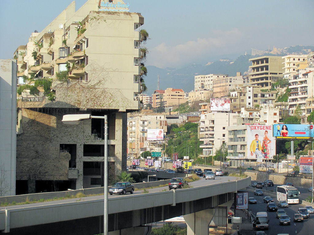
Lebanon is a prosperous little country, a mini-California in its climate and geography. During the long civil war in the 1980s and '90s, many Lebanese citizens fled to other countries (especially the Persian Gulf), where they worked hard and sent home lots of money. For the most part, this was invested wisely in buildings and infrastructure, so even though Beirut and several other Lebanese cities were bombed by the Israeli Defense Forces in 2006, there are very few scars left in busy Beirut. But it would not make much sense for Lebanon to invest heavily in infrastructure until the situation in the Middle East stabilizes and the Lebanese central government is able to assert its authority over the entire country.

Even if politics and international relations weren't tremendous factors, geography would be a big challenge for Lebanon's transportation structure. Most of Lebanon's population lives in a narrow strip of land running north to south along the Mediterranean Sea, hemmed in by mountains that, in places, actually jut out into the sea. Far from being a solid rampart, though, the mountains are riven by steep valleys that run mostly at right angles to the coast.

For some reason, there is very little public transportation in Lebanon. What few buses I saw were weary-looking 20-25 passenger affairs, apparently still in their gray primer paint; mainly Toyota Coasters. But as I mentioned, Lebanon has prospered, and most people seem to own a vehicle of their own. Some are certainly run-down and battered, but there are surprising numbers of new Mercedes and BMWs zooming around. US-brand cars are pretty few and far between, with Japan, Korea, and Germany the main providers, though the French have a solid foothold, and even the Chinese have a small toehold. The result of all this is traffic that makes I-94 at rush hour look like a picnic. It doesn't help that the Arab way of driving is very different from ours, resulting in some pretty hair-raising experiences until you realize that there's a system. Very few accidents actually happen, but it takes a long time to get anywhere, and there are no realistic options besides a car of your own, or a taxi. (I'm so glad I didn't try to rent a car.)

Most of the traffic is concentrated in the coastal zone, which has an expressway reminiscent of I-5 through Seattle or Portland. This is the western backbone of the country, which needs a robust public transportation axis on which to hang a multitude of east-west feeder lines. In effect, that's what the road system does now, but its capacity is inadequate, especially in the Beirut metro area. What a shame the coastal railroad was torn up 20-30 years ago - the capacity of rail is badly needed now. A moderate-speed railway along the coast would be ideal, topping out at 120 kh/h or about 85 mph - no need for a bullet train in this small country. It would need to be at least double-track all the way from north to south, with a 4-track main for local commuter service in the Beirut area.

The main part of the capital juts out on a peninsula into the Mediterranean, and a crescent-shaped rail loop following the coast to the downtown areas would work nicely. But there is a large urban area in a valley extending east from the coastal region. I'd vote for a busway along the east-west expressway into the city as the spine for this area.

In fact, all the east-west lines are ideal for buses. Many of the valleys are very steep-sided - canyons, really - so the settlements are often on the hilly ridges rather than in the valley-bottoms. As a result, the roads leading up from the coast are extremely steep and winding, quite unsuitable for rail, although in some places cable cars or funicular railways might meet short-distance transportation needs. Probably the ideal solution would be trolley buses for towns closer to the coast, and diesel buses for the more distant ones.

Electric buses offer several advantages over diesel in this environment. For one thing, the air is quite polluted in the densely-populated city, and zero-emission vehicles would be a great help. Lebanon generates quite a respectable percentage of its electricity through hydro-electric generating stations, so the pollution wouldn't simply be moved elsewhere. The rapid acceleration of electric vehicles is very valuable on steep hillsides, as you know if you've ridden trolley buses in San Francisco or Seattle. The ability to regenerate electric power while braking on down-slopes could save a considerable amount of energy - not quite enough to power the up-hill vehicles, but enough to help a great deal. Of course, the initial investment is high, but in a relatively prosperous, small, densely-populated metropolitan area like Beirut, it would not be an insuperable obstacle.

Unfortunately, the real obstacle is not so much financial as political. The deep, long-standing distrust between members of the different ethnic and religious groups in Lebanon pose a threat that would make it difficult for investors to justify long-term improvements in infrastructure. What a shame - Lebanon is a beautiful country with tremendous potential for success.

Amman, Jordan

I didn't spend enough time in Amman to make any meaningful observations, except that there are a lot of buses, large and small. Amman was the capital of the ancient Ammonites, mentioned several times in the Old Testament, and like most ancient cities, Amman's streets aren't laid out in anything resembling a grid. However, expressways have been built linking the neighborhoods together, tunneling through some hills and bridging deep gullies where necessary. This is a city where buses make sense, though electric (trolley) buses would be preferable to diesel buses if the capital investment weren't so high. I'm told that most of Jordan's electricity is generated with natural gas, so the overall CO2 would only be reduced a little, but particulate matter would be removed from the city. Probably not worth the investment until the cost of diesel skyrockets.

Jerusalem

The Holy City is a dense, bustling metropolis with a lively public transportation network. As of April 2010, the only public mode is buses, but there is a wide variety of them. Egged, the Israeli public transport cooperative, runs lots of full-size and articulated buses, mainly from the German firm MAN. It's a bit startling to American eyes to be looking at a street which to us appears to be a narrow, quiet residential street, and suddenly see a huge, articulated bus come roaring along it, packed with people, both sitting and standing. In addition to Egged, there is a company called Puma that runs large buses, but they tend to be older and appear accustomed to hard usage.

An American woman, an acquaintance who rides the buses frequently, mentioned that she had gotten on one at about 10 PM one night to go home, and had ended up having to ride it for an hour and a half. Why? Because at one stop, about 40 orthodox Jewish men had gotten on the already well-patronized bus, and were squeezed into a solid mass in the aisle. For a woman to try to push her way through such a mass of Jewish orthodox manhood would be absolutely and totally taboo. So when the bus came to her stop, she had to stay on and ride it around its entire route.

Then there are the mini-buses. These hold 10-20 people and run from the city to the outlying towns. They appear pretty much alike, except that the ones going to Jewish areas have blue stripes, and those going to Palestinian towns have green stripes. Of course, there are also huge, luxurious tour -coaches, which aren't exactly public transportation, but which seem almost more numerous than their humbler public brethren.

Most interesting is the Old City. There is only one kind of transportation there: your feet. The Old City is a maze of narrow passageways, often roofed over, between shops, houses, monasteries, hostels, churches, mosques, yeshivas, more shops, and who knows what else. I went into the Old City a number of times, and when I went alone I never failed to get lost trying to get out. Fortunately, getting lost was more of an adventure than a problem!

The Old City's ways are paved with stones worn smooth by millennia of pedestrians. Many are steep and have steps, but these all have little built-in stone ramps just wide enough for the push-carts used to supply the shops with their goods. I was warned that if you hear a kid yelling behind you, it's best to move to the side quickly, since the youngsters employed to push the carts love to zoom down the hills scattering tourists and residents alike.

The buses run only in the newer parts of the city, which is growing in population and area. So, guess what? Jerusalem is building a light rail system! Several busy streets in the new sections are torn up to make way for the rails and stations, and there is a wonderful, curved suspension bridge designed by the renowned Spanish architect/engineer, Santiago Calatrava. SeƱor Calatrava took a practical problem - a confined, busy space for a tight turn - and created a work of art, a lovely flight of fancy. If more elevated railways combined beauty and utility this way, cities like Chicago would be a wonder to behold.