Saturday, December 28, 2013

Pavement-Guided Buses

Recent Developments in Public Transportation
Topic 1, Part 3

Bus Rapid Transit through Light Rail:
Pavement-Guided Buses

More complex systems for guiding buses (compared to curb-guided systems) make use of markers buried in the pavement or placed on the pavement's surface. These run on have rubber tires, and can be steered either manually or by computer-based hardware/software combinations.
Two systems are out there:
  • "Phileas": uses magnetic beacons embedded in pavement. It was developed by the consortium Samenwerkingsverband Regio Eindhoven (SRE), Netherlands, along with some other companies for the Cooperation Foundation Eindhoven Region - most prominently Advanced Public Transit Systems (APTS), VDL Bus and Coach, and Bombardier. A Dutch company, Frog Navigation Systems, developed the technology known as FROG that uses small magnets embedded in the road surface
  • "Optiguide": uses painted marks on roadway. Siemens (multinational), developed and owns the guidance system. To date, buses guided by Optiguide have been built by Iveco Irisbus (Italian), but probably any company willing to work with Siemens could design buses to use the system.
Both Optiguide and Phileas have a steering wheel for the operator. Guided operation is currently used only when very precise steering is needed. The vehicles can be guided to within an inch or two (5 cm) of the edge of a station platform, making boarding easy for people who depend on wheels of one kind or another to get around.

Phileas

Phileas vehicle (largest configuration)
(Photo: VDL Bus and Coach)

I haven't had a chance to visit a Phileas system, which so far has only been deployed in Eindhoven, Netherlands. A few other cities are in various stages of developing Phileas systems, but the overwhelming evidence seems to be that Phileas is "not ready for prime time".

For starters, there are been serious problems with the motive power. Several energy sources are available, including diesel, compressed natural gas, and straight electric from twin trolley wires. The power systems using fossil fuels are all hybrid (both series and parallel have been tried) but have experienced difficulties with the hybrid transmission systems.

But most serious of all, there have been major problems with the FROG ("Free Range on Grid") magnetic guidance system. FROG automatic guided vehicles have been demonstrated to be effective in controlled environments, hauling cargo in warehouses and manufacturing facilities, and providing shuttle service at airports. But when let loose on the streets of Eindhoven, they proved both reckless and easy to confuse. In automatic mode, they attempted to accelerate the buses to the maximum allowed speed, without regard to pedestrians. They would barrel along and, for various reasons, would stray from their appointed path. They were programmed to apply full braking power immediately upon straying more than 25 cm (about 10 inches) from their path. When this happened - and apparently it did fairly frequently - they would make an "emergency" stop, sending passengers flying. Traffic signals turned out to be another problem: perhaps because of the detector loops embedded in the pavement, the FROG system would become disoriented, signal a fault, and prevent the bus from moving forward.

These problems have proven difficult to overcome. As of last report (September, 2008), Eindhoven transit has discontinued use of the FROG system except for docking, and passengers have been calling it "Phileasco" (Phileas+fiasco). Other cities attracted to the potential of the Phileas system have been unable to procure buses, due to the constant need for the manufacturer to recall their vehicles for modification. As a result, Phileas cannot be considered a realistic option at this time.

Optiguide
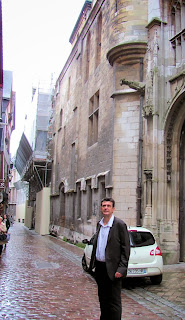
Olivier Rateuivillie
(Photo: L. Krieg)

I was fortunately able to visit Rouen, France, the first city to deploy the Optiguide system, in 2001. (Castellón, Spain is the only other one so far.) Olivier Rateuiville, public affairs officer for the transit authority of Rouen, was kind enough to show me around when I was visiting in October.


The Optiguide system uses a simple pattern of white lines painted on the pavement. In the bus, a sophisticated hardware/software combination detects the guidelines through a video camera and signals the driver when it is about to take over the steering. Unlike FROG, Optiguide does not attempt to control starting, stopping, or speed - these all remain the driver's responsibility. And when necessary, the driver can override the automatic steering.
Rouen BRT with Optiguide
Bus-only lanes (red pavement with guide marks)
Bulge on bus-top houses guidance video equipment
(Photo: L. Krieg)


In Rouen, the buses use automatic guidance only when they are approaching a station on the main BRT route. Rouen built a BRT corridor through the most congested parts of the city, and this corridor is shared by three routes which fan out into different suburbs. Once past the central corridor, the buses run in lanes shared with general traffic, and are operated like standard articulated buses.
Map of Rouen BRT Routes
(Map: CREA; English overlays: L. Krieg)


Here's some video I shot while I was there:

Olivier gave me a presentation - apparently many other cities have sent delegations to observe their Optiguide. This presentation gives an overview of the history and finances, as well as the BRT infrastructure and operation. I was interested to note that operating funds amounting to €372,000 was spent in 2010 for "Guidage véhicule" (vehicle guidance), but did not ask for an explanation. I would have expected the vehicle guidance system to be a capital expense, rather than an operating expense amounting to about 23% of the infrastructure maintenance cost. The capital cost of the Optiguide system is rolled into the vehicle cost, and its actual cost is not readily available.
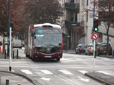
Optiguide in Clermont-Ferrand
(Photo: L. Krieg)

Pros and Cons

Due to the problems with Phileas, I'll list here only the Pros and Cons I see for the Optiguide system:
Pro Con
Flexible: to guide or not to guide, according to needs Pavement must be kept clear
Based on available bus models (potentially multiple vendors) Only one guidance system vendor (Siemens)
Uses well-defined BRT systems Very few installations
More expensive than curb-guidance systems

To learn more:

Tuesday, December 24, 2013

Walking Uphill

Today, I'm taking a break from the "BRT Spectrum" to write a note about walking uphill. Uphill that is, from the current Ann Arbor Amtrak station to University of Michigan Hospital's main entrance. I did this because I've thinking about the walk for many moons, but never actually did it.

Why worry? Because the many people who work at or visit the Hospital (UMH) will be expected to do this if the Ann Arbor station stays at its current location.

You see, the other option is to put the station right by the hospital - the largest single employer, and the fastest growing, in the county. But a number of people in Ann Arbor believe the land next to the hospital would be better off as a park - which it was several decades ago.

My concern is the environmental impact of having a station that's too far to walk to and from. But is it really? Today is December 24, Christmas Eve, so not many people are working (except in hospitals). Traffic was light at 9:30 AM when I set out, but the wind was bitter, sweeping 14 degree air out of the West up Fuller Road at my back. In spite of the uphill trudge, I managed a brisk pace. The warmth of the main hospital entrance was very welcome after 18 minutes. Following a brief warm-up, I headed back down. The sun had finally crested the tops of the hospital complex, the sky was clear, and the temp was up to what felt like a balmy 16. The wind had also moderated, and I only got a couple of frigid gusts as I topped the rise above the Gandy Dancer restaurant. But it took 20 minutes, where I had expected a downhill 15 - the sun must have relaxed me.

OK, so I've never been athletic, and I've even slowed down a bit over the years, but I enjoy walking and do it quite a bit. I guess my walking speed is pretty average, and 20 minutes is a good round number for the time it would take. Google Maps (below) makes the distance 0.9 miles, and walking time 18 minutes, pretty darned close to my reality.
(Click the image to enlarge it)

So how many of the people commuting to UMH would be likely to walk 18 minutes from the train station and 20 minutes back at the end of the day? Thirty-eight minutes out of the day is pretty steep for most twenty-first century people. And many of the folks working at hospitals do so on their feet for eight or more hours every day. I'd say it would be a rare person who'd be willing to give up their car and commute by train+foot to their job if this were California. Factor in Michigan weather, and the number drops even more. And in spite of the efforts of Ann Arbor City Council, we didn't make it to Walkscore's "Top 10 Most Walkable College Towns" (linked below).

Planners often refer to the quarter-mile (400m) limit to people's willingness to walk to transit. (This is said to be somewhat farther in Europe.) Kaid Benfield, of the Natural Resources Defence Council, posted a thoughtful blog (linked below) in July of 2012, in which he discusses various reasons why people are willing to walk longer or shorter distances. I'm afraid the walk from the current station to the hospital doesn't do well on any of the scoring methods he mentions.

Jarrett Walker has an extended discussion of walking distances (linked below) in which he cites the Transit Capacity and Quality of Service Manual, providing this graphic:
(Click the image to enlarge it)

This is interesting because it shows variation in the percentage of people willing to walk in different North American places. Calgary, Alberta, has the most intrepid walkers; citizens of Edmonton - quite a bit further north in the same Canadian province, are willing to walk considerably less far. (Is it that much colder...?)

What's really important is the difference revealed between Washington, D.C., residents of different income levels. Not surprisingly, low income people are willing - or are obliged - to walk quite a bit further than their more fortunate neighbors. Half of them are willing to walk 225 meters, while half of high income people are only willing to walk 100.

What does that say about where we locate the Ann Arbor train station for commuter rail? The distance between the station and the hospital's main entrance is 1448 meters, which vanishingly few people are willing to walk - even in Calgary. Of course, lower income people might walk that far if they had to, but - if the D.C. figures tell the truth about this - higher income people would almost certainly not. Rail commuter service would be subtly pushed into being exclusively for lower income people.

But wait - isn't the current station closer to downtown, anyway? Well, yes. Google puts it 0.7 miles (1125 meters) from the station to the Blake Transit Center (which I'll use as "downtown" for consistency with the WALLY station study). 1125m is still way beyond the distance most people are willing to trudge. So either potential station location is too far for most people to walk downtown.

Unless the train station is moved closer to UMH, practically nobody would walk. They'd have to be bussed. Sounds simple, but I'm told there are serious problems with that option. Depot St. and Fuller St. are narrow, and would be difficult to widen because of the topography and buildings around it, making it difficult for buses to turn around. They would have to go around several blocks, rather than run directly between the station and the hospital. Also, Depot is quite congested during morning and evening peak periods, so both buses and walkers would have difficultly crossing without enforcement of some kind - which, in turn, would cause traffic backups. Fuller Road in front of the hospital, on the other hand, is broad: 4 lanes with left-turn lanes at the hospital entrance and a turnout to reach the place where the station could be built.

All this adds up to one cold, hard fact. Depot Street is not the place for a commuter service station, much less an intermodal transportation center. The hospital location is, with hundreds of buses passing every day, both from the transit authority and the University's student and hospital transportation systems. If the station remains on Depot St., even with a new building and parking facility, rail service will not be a realistic option for most people. Instead, they'll continue driving their cars. The City and the University will continue to build parking structures to store the cars in. City transportation staff will continue tearing out their hair to try to accommodate traffic increases. Drivers will become more frustrated and their commutes will become longer - but without realistic options, that's how it will be.

Just like it is now, only worse.

To learn more:

Saturday, December 14, 2013

Bus Rapid Transit through Light Rail: Curb and Contact Guidance


A full spectrum of options
Recent Developments in Public Transportation, Topic 1 part 2
Continuing the previous post, we're looking at systems for guiding Bus Rapid Transit and similar vehicles. Today, we'll explore contact-guided systems.
Snohomish Community Transit Swift bus
Note the "rub-rail" on the lower yellow portion
of the edge of the platform. Photo: L. Krieg

Contact-guided vehicles

There are a couple of solutions for guiding a vehicle by contact.
Station platform for Eugene, Oregon's EMX BRT
Here, the rub-rail is clearly shown by its yellow paint
Photo: L. Krieg

Tire-guided contact is when there is a "rub-rail" on the sides of station platforms to dock the bus accurately. The "rub-rail" allows the operator to feel positive contact through the tire to the steering wheel, but holds the wheel far enough away from the platform edge to prevent damaging contact to other parts of the bus (such as bumpers, lug nuts, or skirting). This system is used, for example, by Community Transit's Swift service in Everett, Washington.
Snohomish Community Transit's Swift BRT
The bus is docked with the tire against the rub-rail.
Note the size of the gap between platform edge and bus floor (3-4 inches):
A wheelchair would probably need the operator to deploy a bridge in order to cross the gap;
a stroller or walker could probably be maneuvered without a brdige.
Photo: L. Krieg

Contact guidance is only practical at very low speeds; otherwise, wear on the tires becomes expensive and even dangerous. For safe guided navigation in general, a small horizontal guide-wheel is used in contact with a curb or rail.
Mannheim, Germany: guide-wheel on BRT vehicle.
(Note also the protective casing for the lug-nuts.)
Photo: Martin Hawlisch
Wikimedia Commons
. Reproduced under the terms of the GNU Free Documentation License

These wheels can also be used solely for docking - for example, in Cleveland Ohio's Health Line service. For navigation, a rail or concrete lip is installed along the side of the bus lane, as in Adelaide, South Australia's O-Bahn; and the Cambridgeshire Guided Busway in England.
A bus on the O-Bahn Busway route in Adelaide, Australia.
Photo: “Beneaththelandslide”
Wikimedia Commons. Reproduced under the terms of the GNU Free Documentation License

Pros and Cons of Contact-Guided Buses
Pro Con
  • Simple
  • Inexpensive
  • Relatively accurate docking
  • Rub-rails: any contractor can easily install them
  • Rub-rail: Operators say they don't like striking curbs with their vehicle
  • Rub-rail causes tire wear
  • Rub-rail is only applicable for low-speed docking, not for  running in constrained or twisting lanes
  • Guide-wheel: must install steel or concrete guide-rail
  • Guide-wheel: may make unpleasant grinding noise
Cambridgeshire, England Busway
Concrete lip of trackway provides guidance
Photo: Bob Castle
Wikimedia Commons. Reproduced under the terms of the GNU Free Documentation License

To learn more:

Tuesday, December 10, 2013

Bus Rapid Transit through Light Rail


A full spectrum of options
Recent Developments in Public Transportation, Topic 1 part 1
Los Angeles Metro Orange Line BRT vehicle

Questions for Southeast Michigan

As Southeast Michigan begins to implement rapid transit in 2014, the enabling legislation has specified a system using "rolling rapid transit", as defined in the Act. This raises a number of questions:
  • What exactly is "rolling rapid transit"?
  • What types of "rolling rapid transit" systems are available?
  • What are the strengths and weaknesses of each type?
  • Do systems with more aspects of light rail attract more private investment to their corridors?
In September 2013, I spent eleven days in France investigating transit systems in ten cities to try to answer these and other questions. But the first two questions are answered in the legislation that enabled the Regional Transit Authority (RTA) to come into being. Let's take a look there first, so we know what we're talking about.
REGIONAL TRANSIT AUTHORITY ACT
Michigan Public Act 387 of 2012
124.542 Definitions.
Sec. 2. As used in this act:

(o) "Public transportation system" means a system for providing public transportation in the form of light rail, rolling rapid transit, or other modes of public transportation and public transportation facilities to individuals.

...
(r) "Rolling rapid transit system" means bus services that may combine the technology of intelligent transportation systems, traffic signal priority, cleaner and quieter vehicles, rapid and convenient fare collection, and integration with land use policy. Rolling rapid transit may include, but is not limited to, all of the following:
(i) Exclusive rights-of-way.
(ii) Rapid boarding and alighting.
(iii) Integration with other modes of transportation
Los Angeles Foothills Transit. Articulated bus,
same model used by Orange Line, but not used as BRT

Though Sec. (2)(o) includes rail transit, for political reasons rail was made especially difficult to approve:
124.546, Sec. 6 (3) …
(b) A board shall provide in its bylaws that the following actions require the unanimous approval of all voting members of the board:
(i) A determination to acquire, construct, operate, or maintain any form of rail passenger service within a public transit region.

Is this “Rolling Rapid Transit”?

I discovered that, like many aspects of law, there are a number of fuzzy, undefined areas. Among other terms, “Bus” is not defined precisely. When a law does not define a term, an authoritative dictionary definition is generally used. Here is Webster’s Online Dictionary’s definition:
“1. a :  a large motor vehicle designed to carry passengers usually along a fixed route according to a schedule There is actually quite a spectrum of vehicles that fit this definition, from purely rubber-tired, free-steering “buses” to “light rail” vehicles with steel wheels rolling on steel rails.

What, then, is BRT?

Four features differentiate BRT from other types of city bus service – three alluded to in PA 357 Sec. (2)(r):

  • Dedicated lanes
  • Signal priority
  • Stations rather than stops
  • Pay before your board

Also BRT vehicles are usually larger than local transit buses (having two or three articulated sections). Many have wider doors, doors on both sides, or doors that match the height of station platforms. Most have internal combustion engines; a few use electric power from dual overhead wires (the trolleybus system).
Dedicated lanes for Los Angeles Orange Line.
Built on an abandoned railroad right of way.

A Full Spectrum

Between bus rapid transit and light rail, it turns out there's a full spectrum of choices. We'll look at two ways of classifying these systems - by how they are routed and relate to other traffic, and by how they are guided.

Here's an overview of how bus systems relate to other traffic:

  • Arterial Rapid Transit (ART)
    Similar to BRT, but does not have dedicated lanes
    Fewer stops than local transit buses
    Los Angeles Metro Rapid,
    an example of Arterial Rapid Transit

  • Express Bus: urban
    Follows the same general route as a local bus
    Does not stop at all stops in certain areas
    Does not have dedicated lanes
  • Express Bus: commuter
    Takes people from suburb to center city
    Usually has a significant portion of the route on a thruway
    No specifically dedicated lanes, though they often use HOV (High Occupancy Vehicle) lanes
  • BRT “lite”
    Has some features of BRT, but is missing others
    May have BRT features in some places, but not in all.
Los Angeles Metro Rapid bus
This could also be seen as "BRT Lite"

Now about how they're guided

There are a couple of reasons to provide automatic guidance systems for transit vehicles...
  • Docking: this is when the vehicle comes in to a station. The idea is to make it really easy for people to get on and off. To achieve this, the floor of the vehicle and the station platform should be at the same level and very close together - but not touching. This makes it much faster for people to get on and off, and anyone with a wheeled vehicle (wheel chair, stroller, or just baggage) won't have to worry about gaps or steps. It all adds up to getting everybody where they're going more quickly and smoothly.
  • Safe navigation: it's very tricky for a driver to steer a large vehicle through narrow, twisting lanes. It can be done more safely and rapidly if the vehicle is guided by a mechanical or computerized system. If a transit system is to have dedicated lanes, it makes sense to make them as small as possible, to leave as much room as we can for other traffic.
Conventional BRT, which best fits the definition of “rolling rapid transit” given in Public Act (PA) 387, runs on rubber tires and is steered by an operator. Many BRT installations have docking guidance, and some have safe navigation guidance as well.
Los Angeles Metro Silver Line vehicle.
This is BRT that runs on restricted thruway lanes.
It is steered manually by the operator.

If BRT is one end of a spectrum, the other end is Light Rail Transit (LRT), which runs on steel wheels and is steered by steel rails and switches rather than by an operator. The rails serve as a full-time automatic guidance system for both docking and safe navigation.

In between BRT and LRT lie four variants:
  • Vehicles on rubber tires guided by contact with a roadside rail or curb part or all of the time
  • Vehicles on rubber tires guided by optical or magnetic technology part or all of the time
  • Vehicles that run on rubber tires and can be steered by a central steel rail part or all of the time
  • Vehicles on rubber tires that are steered exclusively by a central steel rail
Over the next few blog entries I will be taking a look at each of these four variants. In the first of these we'll see what's available in curb guided guided systems.
Los Angeles El Monte Station
Serves several LA Metro and Foothills Transit bus routes
This is the western terminus of the Silver Line


To learn more: